
Tour Type
Mountain Climbing
Tour Duration
9 Days 8 Nights
Min. No of Pax
1

Tour Price

Budget
On request
Mid-range
On request
Luxury
On request
The Price Includes
- Professional Kilimanjaro mountain guide
- Assistant mountain guides where required according to group size
- Professional mountain cook
- Kilimanjaro mountain porters
- Kilimanjaro National Park entrance fees
- Camping fees
- Hut fees where applicable during the route
- Park rescue fees
- Rongai Route trekking permits
- Tented mountain accommodation during camping stages
- Quality mountain tents
- Dining tent where provided
- Tables and chairs where provided
- Three prepared meals per day while trekking
- Safe drinking water during the mountain expedition
- Tea and coffee during the trek
- Transport from Arusha to the Rongai Route starting area
- Transport from Marangu Gate back to Arusha
- Airport transfers according to the confirmed itinerary
- Accommodation in Arusha before the climb according to the confirmed package
- Accommodation in Arusha after the climb according to the confirmed package
- Pre climb mountain briefing
- Mountain safety monitoring
- First aid equipment
- Emergency oxygen where included within the mountain safety setup
- Pulse oximeter monitoring where used by the mountain team
- Summit certificate for qualifying climbers
- Government taxes applicable to included services
The Price Excludes
- International flights
- Domestic flights unless specifically mentioned
- Tanzania visa fees
- Travel insurance
- High altitude trekking insurance
- Personal trekking equipment
- Sleeping bag unless specifically included
- Hiking boots
- Trekking poles unless specifically included
- Personal clothing
- Toiletries
- Laundry services
- Alcoholic beverages
- Soft drinks
- Meals in Arusha unless specifically included
- Personal snacks and energy products
- Personal medications
- Vaccinations
- Medical expenses
- Emergency evacuation expenses not covered by insurance or park rescue services
- Telephone charges
- Internet charges
- Additional accommodation caused by flight delays or schedule changes
- Tanzania safari extensions
- Zanzibar extensions
- Optional activities
- Tips for mountain guides, cooks and porters
- Personal expenses of any nature
Tour Overview

The 9 Days Rongai Route with 7 Days Hiking is a scenic, relatively remote and rewarding way to climb Mount Kilimanjaro in Tanzania, offering trekkers a distinctive northern approach, quieter early stages, dramatic views of Mawenzi and Kibo, and a memorable summit journey to Uhuru Peak at 5,895 meters above sea level.
Organized by Martial Eagle Adventures, a professional tour company based in Arusha, Tanzania, this itinerary combines arrival and departure arrangements with seven full days of mountain trekking, providing a complete Kilimanjaro climbing experience from the lower northern slopes to the summit and final descent.
The Rongai Route is unique among the major Mount Kilimanjaro climbing routes because it approaches the mountain from the northern side near the Kenya border. While routes such as Machame, Lemosho and Marangu approach Kilimanjaro from the south or west, Rongai provides a different perspective and a quieter wilderness atmosphere during the early stages.
For this reason, it is particularly attractive to travelers seeking a less crowded Kilimanjaro route, scenic Tanzania mountain adventure, 7 day Rongai Route climb, Kilimanjaro northern route trekking experience or alternative to the Machame and Lemosho routes.
The journey begins from Arusha, one of northern Tanzania’s main tourism hubs and an important gateway for Mount Kilimanjaro climbing, Tanzania safaris and cultural adventures.
After arrival in Arusha, guests meet the Martial Eagle Adventures team for a detailed pre climb briefing that covers the route, personal equipment, mountain weather, safety procedures, altitude awareness, camping arrangements, hydration and summit preparation.
The following morning, the expedition travels toward the Rongai Gate area, located on the northeastern side of Mount Kilimanjaro.
The drive is longer than transfers to some southern Kilimanjaro gates because the route circles around the mountain toward the northern side. The journey from Arusha can take approximately 3.5 to 4.5 hours, depending on road conditions, registration procedures and the exact trailhead used.
The lower Rongai slopes are generally drier than the southern side of Kilimanjaro, especially during some parts of the year. This gives the route a noticeably different character.
The trek begins through cultivated land and forest before gradually entering open heath and moorland.
The first major overnight destination is Simba Camp, located at approximately 2,625 meters above sea level.
From Simba Camp, climbers continue through increasingly open terrain toward Second Cave, usually situated around 3,450 meters.
This section begins revealing broad views toward the Kenyan plains and the northern slopes of Kilimanjaro.
The route then continues toward Kikelewa Cave Camp at approximately 3,600 meters, gradually increasing altitude while maintaining relatively manageable hiking distances.
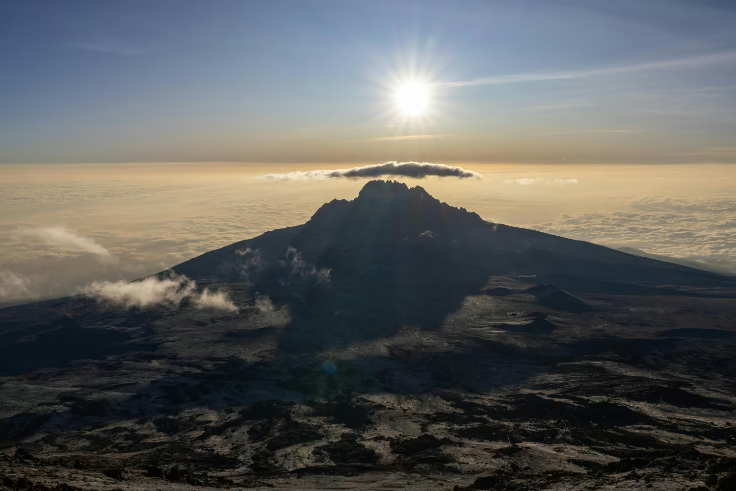
One of the major highlights of the Rongai Route is the approach toward Mawenzi, Kilimanjaro’s rugged secondary volcanic peak.
Unlike the broad and relatively smooth summit dome of Kibo, Mawenzi has dramatic jagged ridges, sharp volcanic spires and a distinctly rugged appearance.
The trek toward Mawenzi Tarn Camp at approximately 4,330 meters places climbers beneath some of the most striking scenery encountered anywhere on Kilimanjaro.
This area also plays an important role in acclimatization.
The gradual progression through Simba, Second Cave, Kikelewa and Mawenzi Tarn gives the body increasing time to adjust to reduced oxygen levels before the demanding summit stages.
The 7 day Rongai Route itinerary is generally considered more favorable for acclimatization than shorter Rongai variations because the extra days reduce the need for large altitude gains.
No Kilimanjaro itinerary can guarantee freedom from altitude sickness, and individual responses to altitude vary greatly, but a gradual ascent generally provides a better framework for acclimatization than rushing toward the summit.
From Mawenzi Tarn, climbers continue across the vast high altitude landscape known as the Saddle, a broad volcanic desert stretching between Mawenzi and Kibo.
This stage is one of the most visually dramatic parts of the Rongai Route.
The landscape becomes almost completely barren.
Vegetation disappears, the air becomes noticeably thinner and the immense summit cone of Kibo dominates the route ahead.
The day’s destination is Kibo Hut at approximately 4,700 meters above sea level, the final major staging point before the summit attempt.
Although Rongai climbers spend earlier nights in tents, the summit approach joins the Marangu Route near Kibo.
At Kibo Hut, trekkers rest, eat an early meal and prepare warm clothing, headlamps, water, snacks and trekking equipment for the most challenging stage of the expedition.
The summit attempt normally begins around midnight.
Climbers leave Kibo Hut in darkness and follow a steep zigzagging trail over volcanic scree toward the crater rim.
The ascent is slow and demanding.
At these elevations, the reduced oxygen makes even simple movement physically challenging, so the guides maintain a deliberately slow pace known in Swahili as pole pole, meaning slowly.
After several hours, climbers reach Gilman’s Point at approximately 5,685 meters, located on Kilimanjaro’s crater rim.
Reaching Gilman’s Point is a major mountaineering achievement in itself.
Those who are physically able to continue follow the rim toward Stella Point at approximately 5,756 meters and finally Uhuru Peak at 5,895 meters.
Uhuru Peak is the highest point on Mount Kilimanjaro, the highest point in Tanzania and the highest point on the African continent.
Depending on pace and conditions, sunrise may illuminate glaciers, volcanic formations and the surrounding plains while climbers continue along the crater rim.
After a short summit celebration, the group begins descending.
Unlike the ascent, which follows the Rongai Route from the north, the descent continues down the Marangu Route on the southeastern side of Mount Kilimanjaro.
This gives climbers the advantage of experiencing different mountain landscapes during the ascent and descent.
After returning to Kibo Hut for a rest, the group descends to Horombo Hut at approximately 3,720 meters.
The final trekking day continues through heath, moorland and rainforest, passing Mandara Hut before arriving at Marangu Gate.
At Marangu Gate, climbers complete park procedures and successful trekkers normally receive the appropriate summit certificate.
A vehicle from Martial Eagle Adventures then transfers the group back to Arusha.
The 9 Days Rongai Route with 7 Days Hiking is particularly suited to travelers who want a less crowded approach, gradual altitude progression, dramatic Mawenzi scenery, a remote northern wilderness experience and a summit descent through a different side of Kilimanjaro.
For travelers researching Mount Kilimanjaro Rongai Route packages, 7 day Rongai Route itineraries, Kilimanjaro trekking from Arusha, Tanzania mountain climbing holidays, less crowded Kilimanjaro routes, Uhuru Peak expeditions and scenic African trekking adventures, this itinerary provides a strong combination of wilderness, acclimatization and summit opportunity.
Tour At A Glance
- Destination: Mount Kilimanjaro, Tanzania
- Route: Rongai Route
- Total Tour Duration: 9 Days
- Mountain Hiking Duration: 7 Days
- Highest Point: Uhuru Peak
- Maximum Elevation: 5,895 meters above sea level
- Starting Side: Northern Kilimanjaro
- Starting Gate: Rongai Gate
- Finishing Gate: Marangu Gate
- Starting City: Arusha, Tanzania
- Mountain Accommodation: Tented camping with Kibo and Horombo mountain facilities during the final stages
- Difficulty Level: Challenging high altitude trekking
- Major Scenic Feature: Mawenzi Peak
- Summit Approach: Via Kibo Hut and Gilman’s Point
- Main Landscapes: Forest, heath, moorland, alpine desert, Mawenzi highlands, volcanic Saddle and arctic summit zone
- Primary Goal: Reach Uhuru Peak, the summit of Mount Kilimanjaro
Day To day
DAY 1: ARRIVAL IN ARUSHA AND KILIMANJARO CLIMBING BRIEFING
Your 9 Days Rongai Route Kilimanjaro adventure begins when you arrive in northern Tanzania and are welcomed by a representative from Martial Eagle Adventures.
Travelers arriving at Kilimanjaro International Airport are transferred to their hotel in Arusha.
The drive between Kilimanjaro International Airport and central Arusha covers approximately 50 to 55 kilometers and generally takes around 1 to 1.5 hours, depending on traffic and the exact accommodation location.
Arusha lies at approximately 1,400 meters above sea level beneath Mount Meru and is one of the most important tourism centers in Tanzania.
The city is a major gateway for Mount Kilimanjaro climbing, Serengeti safaris, Ngorongoro Crater tours, Tarangire safaris, cultural experiences and Northern Tanzania adventure travel.
After checking into your hotel, you meet your professional Kilimanjaro guide for a detailed pre climb briefing.
Your guide explains the Rongai Route itinerary, expected hiking distances, daily elevation changes, campsite arrangements, mountain weather, altitude acclimatization, safety procedures, hydration strategy and summit preparation.
Your trekking equipment may also be checked to ensure you have suitable hiking boots, waterproof clothing, thermal layers, gloves, summit jacket, sleeping bag and other necessary mountain equipment.
Any missing equipment can normally be identified during this stage so that rental or replacement arrangements can be made before departure.
The rest of the day is reserved for relaxation and preparation.
You are encouraged to drink plenty of water, eat a good meal and rest properly before beginning the trek.
Additional Activities That Can Be Arranged
- Arusha city tour
- Cultural Heritage Centre visit
- Local market exploration
- Last minute trekking equipment rental
- Souvenir shopping
- Local restaurant experience
- Short guided city walk
- Relaxation at your hotel
DAY 2: ARUSHA TO RONGAI GATE AND TREK TO SIMBA CAMP
Starting Elevation at Rongai Gate: Approximately 1,950 meters
Simba Camp Elevation: Approximately 2,625 meters
Hiking Distance: Approximately 6 to 8 kilometers
Hiking Time: Approximately 3 to 4 hours
Vegetation Zone: Forest and Lower Heath
After breakfast at your hotel in Arusha, your Martial Eagle Adventures mountain team collects you for the drive toward the Rongai Gate area on the northern side of Mount Kilimanjaro.
The road journey can take approximately 3.5 to 4.5 hours, depending on road conditions, traffic and registration procedures.
The drive provides an interesting introduction to northern Tanzania as the route circles around Kilimanjaro toward the relatively remote northern slopes.
Unlike many climbers who begin on the heavily used southern side of the mountain, Rongai trekkers approach from the area near the Tanzania and Kenya border.
Upon reaching the registration area, park procedures are completed while porters organize expedition equipment, food, tents and group supplies.
The trek begins through farmland and forest before gradually entering more open vegetation.
Compared with the wetter southern slopes, the northern side of Kilimanjaro often has a somewhat drier character.
The hiking distance to Simba Camp is approximately 6 to 8 kilometers, normally requiring around 3 to 4 hours.
The trail gains roughly 600 to 700 meters in elevation, making this a manageable introduction to the trek.
Wildlife sightings are unpredictable, although the northern forest zone may provide opportunities to see monkeys and mountain birdlife.
As the trail climbs, surrounding vegetation becomes progressively more open.
Eventually you arrive at Simba Camp at approximately 2,625 meters above sea level.
The campsite provides your first experience of sleeping on Mount Kilimanjaro.
Your crew prepares dinner while your guide conducts an evening briefing about the following day’s journey toward Second Cave.
Additional Experiences Along This Stage
- Northern Kilimanjaro landscape photography
- Forest birdwatching
- Wildlife observation
- Local vegetation interpretation
- Views toward the Kenyan plains when conditions allow
- Short acclimatization walk near camp
- Sunset observation
- Introduction to mountain camping
DAY 3: SIMBA CAMP TO SECOND CAVE
Starting Elevation: Approximately 2,625 meters
Second Cave Elevation: Approximately 3,450 meters
Hiking Distance: Approximately 8 to 9 kilometers
Hiking Time: Approximately 4 to 5 hours
Vegetation Zone: Heath and Moorland
After breakfast at Simba Camp, the trail continues steadily upward through increasingly open heath and moorland.
The vegetation becomes lower as altitude increases.
Tall trees gradually disappear and are replaced by grasses, shrubs, heathers and specialized high altitude plants.
The northern landscape often feels open and expansive.
On clear days, trekkers may enjoy wide views toward the plains stretching across northern Tanzania and southern Kenya.
The hiking distance is approximately 8 to 9 kilometers, normally requiring around 4 to 5 hours.
The day’s altitude gain is substantial, with the route climbing to Second Cave at approximately 3,450 meters above sea level.
As you gain elevation, the summit areas of Kilimanjaro become increasingly visible.
The vast dome of Kibo begins appearing ahead, while the rugged slopes of Mawenzi become more prominent toward the east.
The route is generally gradual compared with some steeper Kilimanjaro trails, but the increased elevation means maintaining a slow pace is important.
Your guides encourage the group to walk pole pole, allowing the body time to adjust.
Upon reaching Second Cave, lunch or afternoon refreshments are served depending on the day’s timing.
The campsite provides an excellent location for mountain photography and acclimatization.
The drier northern climate can sometimes provide impressive night skies when cloud cover is limited.
Additional Experiences Along This Stage
- Views of Kibo
- Mawenzi photography
- Kenyan plains photography
- Moorland vegetation observation
- Acclimatization walking
- High altitude landscape photography
- Sunset viewing
- Stargazing
- Mountain ecology interpretation
DAY 4: SECOND CAVE TO KIKELEWA CAVE CAMP
Starting Elevation: Approximately 3,450 meters
Kikelewa Cave Camp Elevation: Approximately 3,600 meters
Hiking Distance: Approximately 6 to 8 kilometers
Hiking Time: Approximately 3 to 5 hours
Vegetation Zone: Heath, Moorland and Alpine Transition
Today’s trekking stage continues from Second Cave toward Kikelewa Cave Camp, gradually traversing the northeastern slopes of Kilimanjaro.
Unlike the previous day, the increase in sleeping altitude is relatively moderate.
This makes the stage useful for acclimatization because climbers remain around the mid 3,000 meter elevation range while continuing to move through the mountain environment.
The route covers approximately 6 to 8 kilometers and generally requires around 3 to 5 hours.
The trail crosses open, increasingly rugged terrain.
Vegetation becomes more sparse as the route progresses, indicating the transition from moorland toward higher alpine conditions.
The most dramatic visual feature of this stage is Mawenzi Peak.
Mawenzi rises to more than 5,000 meters and is Kilimanjaro’s second highest volcanic cone.
Unlike the broad rounded profile of Kibo, Mawenzi is heavily eroded, with steep ridges, jagged pinnacles and dramatic volcanic formations.
As you move toward Kikelewa, Mawenzi becomes increasingly dominant.
The campsite lies at approximately 3,600 meters above sea level, providing another important night for acclimatization.
Because the day’s trek is comparatively moderate, there is usually time during the afternoon for rest, hydration and optional short walks around camp.
Climbers should continue paying close attention to appetite, hydration, sleep quality and possible altitude symptoms.
Additional Experiences Along This Stage
- Mawenzi Peak photography
- Acclimatization walking
- High altitude landscape photography
- Volcanic geology interpretation
- Observation of changing vegetation
- Sunset viewing
- Stargazing
- Rest and recovery
- Guide led discussion about altitude adaptation
DAY 5: KIKELEWA CAVE CAMP TO MAWENZI TARN CAMP
Starting Elevation: Approximately 3,600 meters
Mawenzi Tarn Camp Elevation: Approximately 4,330 meters
Hiking Distance: Approximately 5 to 6 kilometers
Hiking Time: Approximately 4 to 5 hours
Vegetation Zone: Alpine Desert
After breakfast at Kikelewa Cave Camp, the route climbs more steeply toward one of the most dramatic campsites on the Rongai Route, Mawenzi Tarn Camp.
The hiking distance is relatively short at approximately 5 to 6 kilometers, but the elevation gain of around 700 meters makes this a physically significant stage.
The trail gradually leaves the remaining moorland vegetation behind and enters the harsher alpine desert environment.
The air becomes cooler and noticeably thinner.
Vegetation becomes sparse as volcanic rock and open high altitude terrain dominate the landscape.
Mawenzi grows increasingly impressive as the trail approaches the mountain’s northern and northeastern ridges.
Eventually the group reaches Mawenzi Tarn Camp at approximately 4,330 meters above sea level.
The campsite is positioned beneath the towering volcanic ridges of Mawenzi and is widely regarded as one of the most scenic locations on the Rongai Route.
A small tarn may be present depending on seasonal conditions, adding to the unusual high altitude atmosphere.
The dramatic cliffs above camp create an almost amphitheater like setting.
Because the day’s sleeping elevation is significantly higher than Kikelewa, climbers are encouraged to rest after arrival and continue drinking sufficient water.
Depending on group health and weather conditions, your guide may lead a short acclimatization walk to a higher point around the Mawenzi area before returning to camp.
This additional exposure to altitude can help prepare the body for the next stage across the Saddle toward Kibo.
Additional Experiences Along This Stage
- Mawenzi Tarn photography
- High altitude acclimatization walk
- Mawenzi volcanic ridge viewing
- Alpine desert observation
- Geological interpretation
- Mountain landscape photography
- Sunset viewing
- Stargazing under clear skies
- Rest and recovery at camp
DAY 6: MAWENZI TARN CAMP TO KIBO HUT ACROSS THE SADDLE
Starting Elevation: Approximately 4,330 meters
Kibo Hut Elevation: Approximately 4,700 meters
Hiking Distance: Approximately 8 to 10 kilometers
Hiking Time: Approximately 5 to 7 hours
Vegetation Zone: Alpine Desert
Day six takes you through one of the most dramatic and remote landscapes on Mount Kilimanjaro.
After breakfast beneath Mawenzi, the trail leaves the rugged volcanic ridges and begins crossing the broad high altitude plateau known as the Saddle.
The Saddle lies between Mawenzi and Kibo, connecting Kilimanjaro’s two major volcanic cones.
The landscape is stark and almost completely barren.
Very little vegetation survives here.
Instead, the route crosses open volcanic desert characterized by dusty trails, rocks, strong sunlight and cold wind.
The contrast between the jagged profile of Mawenzi behind you and the immense rounded summit cone of Kibo ahead creates one of the most memorable views of the entire Rongai Route.
The hiking distance is approximately 8 to 10 kilometers, generally requiring around 5 to 7 hours depending on pace and weather conditions.
Although the elevation gain is comparatively moderate, the entire stage takes place above 4,000 meters, meaning the reduced oxygen can make the walk more tiring than the distance suggests.
The group maintains a slow, steady pace across the Saddle.
Eventually you arrive at Kibo Hut at approximately 4,700 meters above sea level.
This is the final major staging area before the summit attempt.
After arrival, climbers have an early meal and begin preparing for summit night.
Your guide explains the route toward Gilman’s Point, expected temperatures, walking pace, clothing system, hydration plan and emergency procedures.
You organize essential summit equipment including warm base layers, insulated jackets, gloves, headlamp, trekking poles, water and snacks.
The remainder of the afternoon and early evening is dedicated to rest.
Most groups begin the summit climb around midnight.
Additional Experiences Along This Stage
- Crossing the Kilimanjaro Saddle
- Mawenzi photography
- Kibo summit cone photography
- Alpine desert landscape photography
- Summit preparation
- Equipment inspection
- High altitude acclimatization
- Early evening rest
- Final summit briefing
DAY 7: KIBO HUT TO GILMAN’S POINT, UHURU PEAK AND DESCEND TO HOROMBO HUT
Starting Elevation: Approximately 4,700 meters
Gilman’s Point Elevation: Approximately 5,685 meters
Stella Point Elevation: Approximately 5,756 meters
Uhuru Peak Elevation: 5,895 meters
Horombo Hut Elevation: Approximately 3,720 meters
Total Hiking Distance: Approximately 16 to 20 kilometers
Total Hiking Time: Approximately 12 to 16 hours
Vegetation Zones: Arctic Summit Zone to Moorland
This is the most challenging and rewarding stage of your 9 Days Rongai Route Kilimanjaro expedition.
The summit attempt normally begins around midnight.
After a hot drink and light snack, climbers leave Kibo Hut wearing their warmest clothing and follow the guides into the darkness.
The initial trail climbs steeply over loose volcanic scree.
Movement is deliberately slow.
At approximately 5,000 meters and above, the reduced oxygen makes physical activity significantly more demanding.
Even climbers in excellent physical condition may find that walking requires greater concentration and effort.
The guides maintain a consistent pole pole rhythm to help climbers conserve energy.
The ascent continues through the night toward Hans Meyer Cave, an important historical landmark along the summit trail.
After passing the cave area, the trail becomes increasingly steep as it approaches the crater rim.
Temperatures can fall well below freezing, especially before sunrise.
Strong winds may make the conditions feel significantly colder.
After several difficult hours, climbers reach Gilman’s Point at approximately 5,685 meters above sea level.
Gilman’s Point sits on the crater rim and represents a major achievement.
Climbers who are physically able to continue begin following the crater rim toward Uhuru Peak.
The route passes through the high arctic environment of Kilimanjaro, with glaciers and volcanic crater formations visible when weather conditions permit.
Depending on your pace, sunrise may appear during this section.
The first light of morning can illuminate Mawenzi, the crater rim and the vast plains far below.
After continuing along the rim and passing the area around Stella Point, climbers reach Uhuru Peak at 5,895 meters above sea level.
Uhuru Peak is the highest point in Africa.
Standing here represents the culmination of seven days of trekking through forests, moorlands, volcanic deserts and extreme high altitude terrain.
Time at the summit is normally limited because of cold temperatures and reduced oxygen.
There is an opportunity for photographs and a brief celebration before beginning the descent.
The group returns toward Kibo Hut, where climbers normally stop for food and a short rest.
The trek then continues much farther downhill toward Horombo Hut at approximately 3,720 meters.
The total trekking day may last around 12 to 16 hours, making it by far the longest and most physically demanding day of the itinerary.
Upon reaching Horombo, the thicker air and warmer conditions are usually a welcome relief.
Dinner is served before a well deserved rest.
Additional Experiences Along This Stage
- Gilman’s Point achievement
- Sunrise from Kilimanjaro crater rim
- Uhuru Peak summit photographs
- Glacier viewing
- Arctic summit landscape photography
- Views of Mawenzi
- Kilimanjaro crater rim experience
- Summit celebration
- Long descent through changing ecological zones
DAY 8: HOROMBO HUT TO MARANGU GATE AND RETURN TO ARUSHA
Starting Elevation: Approximately 3,720 meters
Mandara Hut Elevation: Approximately 2,700 meters
Marangu Gate Elevation: Approximately 1,870 meters
Hiking Distance: Approximately 19 to 20 kilometers
Hiking Time: Approximately 5 to 7 hours
Drive to Arusha: Approximately 2.5 to 3 hours
After breakfast at Horombo Hut, you begin the final trekking day of your 7 day Rongai Route Kilimanjaro climb.
This stage follows the Marangu Route downward through several vegetation zones.
The trail initially descends across open heath and moorland.
As altitude decreases, temperatures become warmer and vegetation gradually becomes denser.
You pass Mandara Hut at approximately 2,700 meters, where a short break may be taken before continuing into the montane rainforest.
The rainforest creates a dramatic contrast with the dry upper slopes you experienced during the previous days.
Tall trees, giant ferns, vines, mosses and humid forest air surround the trail.
The descent from Horombo to Marangu Gate covers approximately 19 to 20 kilometers.
The walk generally takes around 5 to 7 hours.
Although descending requires less cardiovascular effort than climbing, the long distance can still be tiring after the previous day’s summit marathon.
The trail can also become muddy or slippery after rainfall.
Trekking poles may therefore remain useful.
Eventually you arrive at Marangu Gate, where your Mount Kilimanjaro trek officially comes to an end.
Final park procedures are completed, and successful climbers normally receive summit certificates according to the highest point reached.
This is also a special opportunity to celebrate the achievement with your mountain crew.
After saying goodbye to the guides, cooks and porters, you board your Martial Eagle Adventures vehicle for the return journey to Arusha.
The drive normally takes approximately 2.5 to 3 hours.
Upon reaching your hotel, you can enjoy a warm shower, clean clothing and a well deserved evening of rest.
Additional Activities That Can Be Arranged
- Post climb celebration dinner
- Massage or wellness treatment
- Arusha city exploration
- Souvenir shopping
- Local restaurant experience
- Tanzania safari extension
- Zanzibar beach holiday
- Materuni Waterfalls excursion
- Chemka Hot Springs day trip
DAY 9: DEPARTURE FROM ARUSHA OR CONTINUE YOUR TANZANIA ADVENTURE
After breakfast at your hotel, your 9 Days Rongai Route Kilimanjaro adventure with Martial Eagle Adventures comes to an end.
Depending on your international flight schedule, you may spend additional time relaxing in Arusha before your transfer to Kilimanjaro International Airport.
For travelers with additional days in Tanzania, completing the Rongai Route can be followed by a spectacular Northern Tanzania safari.
Arusha provides convenient access to world famous wildlife destinations including Serengeti National Park, Ngorongoro Crater, Tarangire National Park and Lake Manyara National Park.
A safari after Kilimanjaro gives travelers the opportunity to exchange trekking boots for a safari vehicle and discover Tanzania’s elephants, lions, giraffes, zebras, wildebeest and other iconic wildlife.
Travelers seeking relaxation may instead continue to Zanzibar, where white sand beaches and the warm Indian Ocean provide an ideal contrast to the cold summit environment of Kilimanjaro.
Martial Eagle Adventures can customize these extensions according to your available time, budget and preferred travel style.
Optional Post Climb Extensions
- Serengeti National Park safari
- Ngorongoro Crater safari
- Tarangire National Park safari
- Lake Manyara National Park safari
- Arusha National Park tour
- Zanzibar beach holiday
- Stone Town cultural experience
- Materuni Waterfalls and coffee tour
- Chemka Hot Springs excursion
- Maasai cultural experience
At Martial Eagle Adventures, every journey is thoughtfully crafted around you. We move beyond rigid schedules to offer flexible, tailor-made itineraries shaped by your interests, preferred pace, and travel style. Our experienced travel specialists work closely with you from the very beginning, designing a personalized adventure that reflects the true spirit of Tanzania. This is not just a trip, it is your journey, your story, and an unforgettable experience that goes above and beyond expectations.
Read Reviews

Follow us
- Martial Eagle Adventures
- @martialeagleadventures
- +255 652 283 399
- +255 652 283 399
- sales@martialeagleadventures.com
- Arusha, Tanzania
We Accept